Cima dell'Uomo & Pizzo di Vogorno: a fantastic autumn hike in the canton of Tessin
- Sam

- Jul 20, 2025
- 10 min read
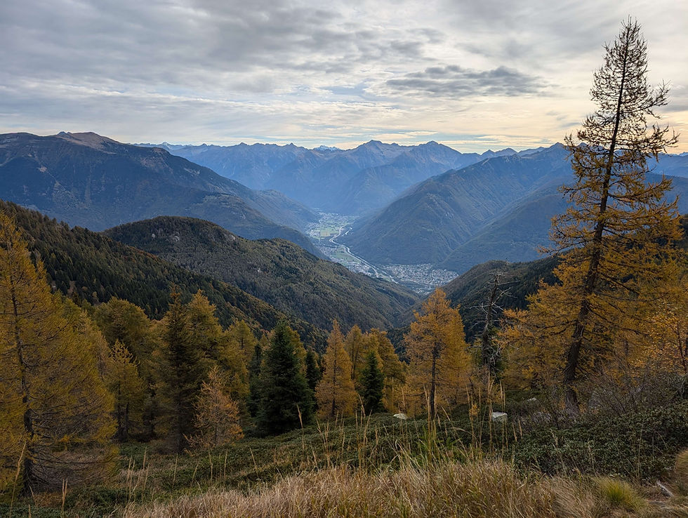
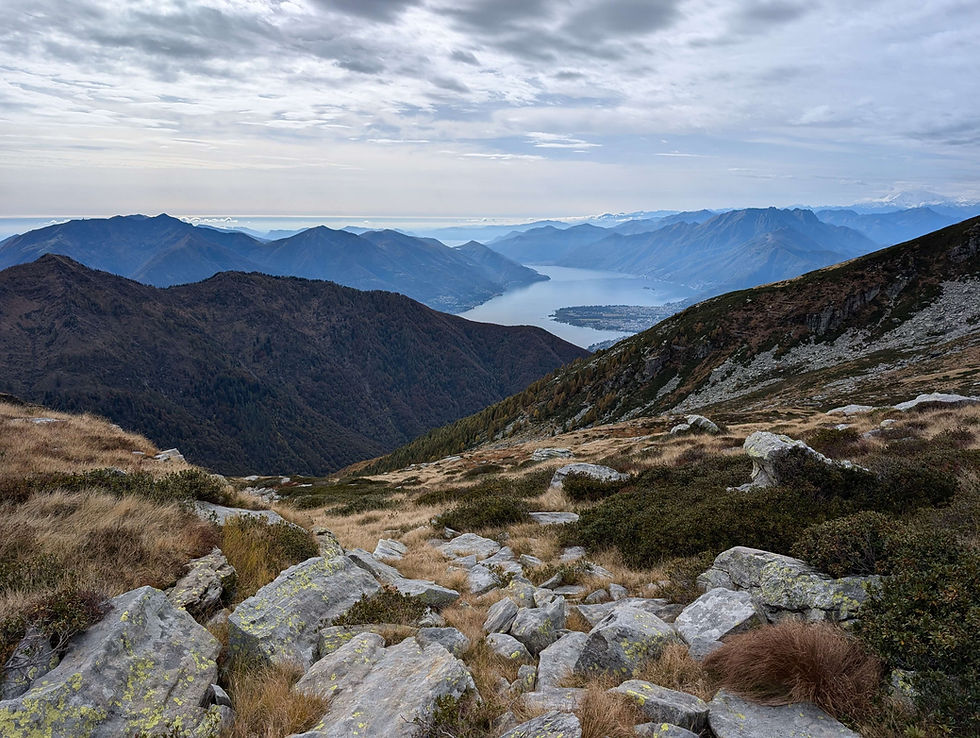
When I had a week off work in the middle of October, I decided to pay our most southern canton another visit. Staying in a hotel in Locarno, Cima dell'Uomo was the designated mountain that I wanted to scale and having a closer look on the map, I thought it a good idea to include the Pizzo di Vogorno as well. :) Usually, the south of Switzerland gets all the sunshine, but when I was there, there was a lot of rain and the weather in general was pretty unstable. So, I chose the best possible day for that adventure and if you want to know if I got wet or not, then just keep on reading. :) Heading out of Locarno in the early morning, I made my way to the Monte Carasso cable car in Bellinzona and skipped the first 1000 meters of difference in altitude with the ride to Mornera. In Mornera, I had to learn that the trail I wanted to take was closed due to some nearby construction work and so, I first had to figure out which way I had to go. Finding the shortest detour on the map, I soon had gone round the construction site and eventually began to walk on the official hiking path. Not surprisingly, the start was in the forest and there were no views for the first 40 minutes. Only a lovely small pond made me stop for a minute on the otherwise straightforward trail. Luckily, the slope was gentle in the beginning, but that was about to change once the trees started to recede. Less trees meant better views though and not only the mountain range I was heading for came into view, but there also were some beautiful outlooks towards the valley of Bellinzona and Locarno.

From now on, the path led upwards rather steeply and despite the many clouds in the sky, I was drenched in sweat before long. :) Coming to a viewpoint a bit further up, the ideal spot for a first break was already taken by two other hikers and so I decided to move on in the direction of the Capanna Albagno. Having to go round a bigger rock formation shortly afterwards, the path led to the right side of it, diminishing the view towards the mountains, but instead opening up a gorgeous lookout into the Valle di Gorduno.
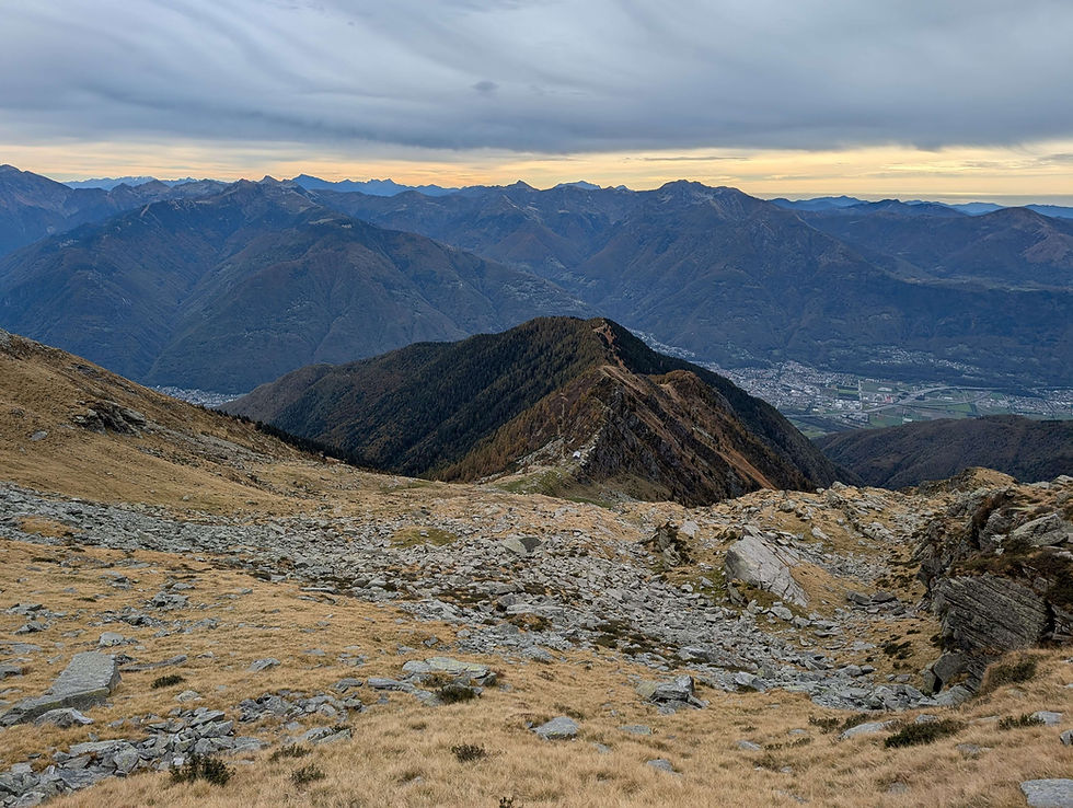
The ascent mostly remained steep in that part, but the trail eventually leveled off before the Capanna Albagno and once I had reached the mountain hut, it was time to sit down and rest for a while. As the clouds in the sky had kept on gathering, I checked the weather radar towards the end of the break and unfortunately, it didn't look very promising. While the evening before the prediction had been no rain at all, there now was a rain front moving straight in my direction. Naturally, I had taken my rain gear with me and as it seemed to be the only front around, I decided to move on anyway. :) Having seen what was awaiting me next, I braced myself for the upcoming part, as right ahead of me was another steep slope. While the steep slopes before had been relatively short, that one was rather long, but at least, with the altitude, there also came some good views. Stopping every now and then during the ascent, the outlook towards Bellinzona and the mountains around it was simply superb.
Slowly, but steadily coming closer to the mountains I had seen from afar already, I was curious which one of them Cima dell'Uomo would be and actually was a bit surprised when the trail started to lead around the peaks in front of me. Hmm, was the summit not in sight yet? Following the trail, I soon came upon a gap in the rocks where I had to cross to the other side and while the path before had been well maintained, it now changed to one full of stones and debris.

Carefully I descended for the next five minutes, turned left at the bottom of the slope and eventually could see the top of Cima dell'Uomo ahead of me. :)

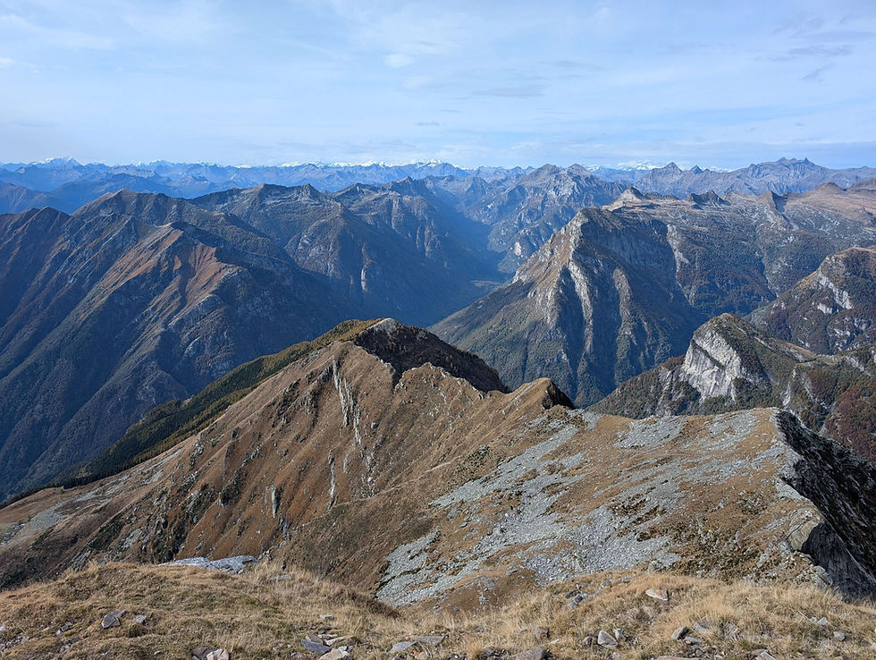
Walking along a mountainside full of scree, the trail led to another gap where I passed a bigger group that were heading to the Cima dell'Uomo as well. On the other side of the gap, the rocky trail continued along another mountainside and while the magnificent views made their return, I wondered if I would make it to the top before it started to rain.
Reaching the turnoff to the summit before long, I started directly with the final ascent and even though it was marked as a red and white trail, it involved quite some scrambling. About ten minutes later, I had reached the top and looking towards the rain front at first, I was happy to see, that it was passing by a few kilometers north of where I stood and so it was no problem to sit down, eat my lunch and take a good look at the stunning surroundings. Also the bigger group that joined me on the peak a bit later on didn't disturb my peace and when I left about 50 minutes later, I did it with a smile on my face. :)
Having seen most of today's second part from above, I decided to first of all head down to the Capanna Borgna and then see from there if it was possible to scale the Pizzo di Vogorno as well. Not surprisingly, the descent was steep and I was losing height pretty fast. Nevertheless, I enjoyed the lovely path, the gorgeous view towards the Madonetto mountain range and the rapidly improving weather.

Down and down it went and after about 40 minutes of descending, I arrived at the Capanna Borgna. Unfortunately, the hut was closed due to the renovation of some parts of it, as otherwise it would have been a nice place to take a break. Instead, I opted to head into the direction of the Pizzo di Vogorno, as the weather was looking good, I had enough time and I knew that the final decision whether to scale it or not was to follow only a bit later on. So, taking a right turn at the hut, I started to ascend again. The ascent was steep in places, but overall the going was fairly gentle, allowing me, for the next half an hour, to make good way.
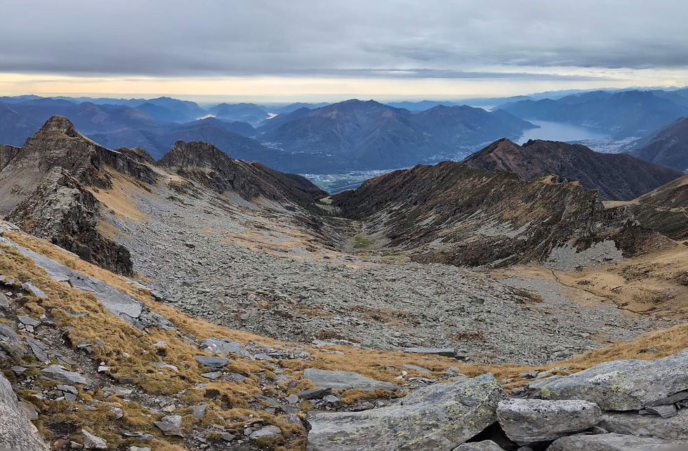
Eventually approaching the next turnoff, the time had come to take the final decision. It was the last possibility to head down into the valley without visiting Pizzo di Vogorno, but in the end I decided against it, as I had the time and knew that I also had the stamina to do the long descent from the peak. Taking a right turn at the turnoff, the ascent got steeper right away and when I reached another junction about ten minutes later, I turned left and headed towards an impressive looking rock formation. The trail led along the foot of it and I was a bit surprised when two other hikers passed me on their way down, as it was already past 2 o'clock in the afternoon. Well, the path went round the rock formation and at the end of it a super steep slope was awaiting me. Luckily, it wasn't a long one, but because it was quite slippery, I really had to take care during the ascent. Coming to the end of the slope, twelve eyes were looking at me, as a family with their dog was already waiting to go down. :) Passing them by, my mouth fell open instantly, when my eyes caught sight of the absolutely fantastic view towards the Lago Maggiore and its surrounding mountains. Being totally blown away by that scenery, I had to take a short break to fully appreciate it. :)

Eventually turning around to face today's final ascent, I had to catch my breath for a second time. While I had thought the slope before was steep, the one that loomed ahead of me was even steeper. Well, there was no turning back now and slowly I clambered up that impressive slope. Finally approaching the top of Pizzo di Vogorno, I could see from a distance, that there were still some other people up there. Surprisingly enough, it was another family with a dog and as it was already three o'clock, I wondered if they had enough time to get down the mountain. Starting to chat with each other once I stood on the top, I learned that they didn't have to go down all the way into the valley, as they stayed in a vacation home somewhere in the middle of the mountain. Well, they left about 15 minutes after my arrival and so I had the summit for myself for the next half an hour. :)
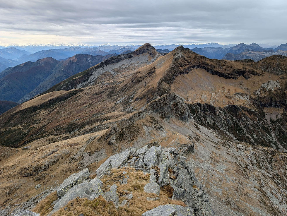
The view was actually even better than from Cima dell'Uomo and left me quite speechless. No doubt it was the best half an hour of today and that also was, because the weather was perfect in the meantime, the sun enlightening all the autumn colors around me.

I wished I could've stayed longer than those 45 minutes, but as it already was a bit late, there was no other option than to start with the long descent into the Valle Verzasca. At first a blue and white trail was waiting for me and while right after the beginning a somewhat challenging part had to be conquered, the rest of the descent to Bardughè wasn't actually that difficult.

There was a short ridge walk as well, but it wasn't too exposed and while there were some super steep slopes in between too, they also weren't the biggest challenges. The biggest challenges were first, to navigate around all the debris on the trail and second, to keep the eyes on the path and not on the still magnificent scenery. :)

It took me over an hour to reach Bardughè and sitting down on a bench in the middle of the hamlet, it was time for a last break. Knowing what was coming, I steeled myself for a long descent in the woods with numerous serpentines. On the map, the way didn't look appealing at all, but there was no other choice and so I left Bardughè once I had gathered enough energy to move on. Enjoying the last good views, I soon ventured into the forest and was ready for a tough and dull descent.

Surprisingly enough, as fast as I had entered the forest, as fast I was out of it again and the best part of the next hour actually turned into a very lovely descent. Thanks to the many serpentines, it never got too steep and because there were almost no trees, the gorgeous view towards the artificial Lake of Vogorno remained a steady companion.

Only when I reached a cluster of vacation homes, the trail eventually led into the woods and the views were gone for good. As I had half of the descent already behind me, that wasn't a big issue anymore and steadily I followed the serpentines down the mountain until I had reached the hamlet of Costa Piana. From there I mostly followed some paved streets all the way to the town of Vogorno. Arriving there around 7 o'clock in the evening, a long day ended with a bus ride back to Locarno. Well, what a great day that was! Not only the weather had been fantastic, but the two peaks were an absolute highlight of my hiking life so far and I'm definitely going to revisit them someday. :)
Highlights of the day: the view from both peaks
This hike is for you if:
- you want the best views over the Alps of southern Switzerland
- you don't mind steep and long ascents/descents
- you're looking for a technically challenging trail
- you don't mind a long day out :)
This hike is not for you if:
- you mind sharing the trail/summit with other people
- a descent of over 2000 meters is too much for you
- it's your first mountain hike in Switzerland


Comments