
Visiting the Lidernen hut on a lovely but cloudy weekend hike

Due to my hiking guide training and other circumstances, I was quite a bit late organizing this year's hut hike. Usually, I book the hut at the very beginning of the year, but when I finally took a look in April, it wasn't that easy to still find a hut with enough space for me and my six friends that wanted to join. In the end, the best option among the few possible huts was the Lidernen hut, as it was reachable easy enough and there were plenty of nice trails in the area. Unfortunately, Flo and Rocio fell ill the day before the hike and couldn't tag along, so in the end there were only five of us. As usual, my friends didn't know where we were heading to, just that the start was in Flüelen at about 09:45 in the morning. Meeting up on the train, Tamina, Claudio, Mark, Friitig and I were looking forward to spend a lovely weekend in the Alps of Central Switzerland. :) Arriving in Flüelen, we decided not to take the bus, but instead walked to the Eggberge cable car to warm up our legs. Reaching the valley station about 15 minutes later, we were right on time to catch the cable car and soon were heading up into the clouds. Skipping a good 1000 meters in altitude, we had reached Eggberge before long. 10 minutes later, we were on our way and at first followed a gravel road for quite a while, gently heading upwards. Our first goal was the Hüenderegg and when we arrived at the designated turnoff, we were the only ones turning in that direction. A steep ascending slope was looming ahead of us and so, my friends already complained for the first time, as they would rather have continued to walk along the flat road. :)

Slowly heading upwards, the slope leveled off soon enough and for the first and only time this weekend we entered a proper forest. The part that now followed was just gorgeous, as the trail was wide, the ascent was gentle, the sun was still shining and to our surprise, there even were some cows and donkeys grazing between the tall firs.

Eventually coming to the edge of the forest, we already could see the cross of Hüenderegg ahead of us and after a very short but very steep ascent, sat down on the bench below the cross. It was about time to take a break and enjoy the view. Well, at least the small part that wasn't covered by the clouds. :) In theory, we could have seen a big part of the Alps of Central Switzerland, as well as the way we were about to take to the hut, but today, almost all of it was behind the clouds. Also the sun was gone for good, but our spirits weren't dampened by that and once we had rested enough, we descended to the Lake Fläsch with its adjoining restaurant.

As we just had had a break, we passed both lake and restaurant and carried on towards the Chalberweid where we came upon a junction. Deciding to do a short detour, we didn't go up the super steep slope directly in front of us but instead turned right and at first followed a wide gravel road through a beautiful area full of huge rocks and single trees. Once that section was behind us, a turnoff appeared and turning left we started to walk along a mountainside. The clouds were thick in that part and we couldn't see a thing anymore. Nevertheless, it was no problem to find the way and slowly we ascended towards Schön Chulm.

Following a narrow trail that by now was full of debris, the path only widened again once we came upon the end of the steep slope that we had avoided with our detour. Well, the rest of the ascent to Schön Chulm was fairly steep as well and while Tamina and Mark put down the accelerator and headed upwards rather fast, Claudio, Friitig and I took it a bit more gentle. :)

Eventually coming upon a vast plateau, the alp Schön Chulm with its cozy restaurant finally appeared and while it would have been a nice spot for our lunch break, there simply were way too many people and so we decided to keep on walking. Turning right, we passed the restaurant and started to ascend again, this time along a wide, but fairly muddy trail.

The ascent was pretty short however and before long we had reached a pass where we had the opportunity to scale a summit called Siwfass. As we expected no one else up there and it wasn't too far away either, we thought it would be a good option for our lunch break. Therefore, we began to walk along a well-trodden, but unmarked trail, leading us at first through a meadow. A turnoff appeared not much later on and turning right, we started to ascend a fairly steep slope. All in all, it took us less than 10 minutes to reach the peak and as there really was no one else up there, we had the summit all to ourselves for the next 50 minutes. Sitting down to eat our lunch, the still reigning clouds opened up about halfway through our break and gave us a glimpse of how stunning the view from there actually would have been. Well, the gap in the clouds didn't last very long and when we left at around two o'clock, there was nothing to be seen once more. :)

Retracing our steps to the pass, we eventually began our descent towards the Lidernen hut. While there were some pretty steep parts in the beginning, the trail leveled off a bit further down and led more gently in the direction of the Spilauer lake. The lake could be seen from far above already, but only when we got closer did it show its whole magnificence.

In theory, it had been the plan to go for a swim in the lake, but as the weather remained as it was, none of us had any desire to take a bath. So, instead of going down to the shore, we carried on towards the Spilauer lake restaurant, which unfortunately was closed on that day. That was a good excuse for my friends to keep complaining, but as I knew that the Lidernen hut, and with it a well-deserved drink, wasn't too far away anymore, the complaints faded away quickly. :) Passing by the restaurant, we descended into a valley on the other side and once we had reached its bottom, took the opportunity to get a closer look at the lake.

Moving on before long, we followed a wide trail along the bottom of the valley until we came upon a turnoff, where we took a right turn. A lovely path led through a maze of rocks and after we passed a couple farmhouses, the Lidernen hut suddenly appeared in front of us. Being only half past three, it was almost a bit early, but from experience I knew that the time in a hut can pass pretty fast. It wasn't much different today, as we drank our well-deserved beer, cleaned our bodies from the dirt of the trail, played some cards, had a fantastic dinner and a fun chat with our dinner table neighbors. :) Bedtime was upon us at about 9 o'clock and we settled down for a good night's rest. Well, as good as it was possible anyway, as in a cramped mountain hut the sleep is usually far from perfect. :) Getting up at around seven in the morning, a look outside immediately brightened our sleepy mood, as there wasn't a single cloud to be seen. What a blessing after yesterday!

After a hearty breakfast, we hit the trail at about a quarter past eight and at first headed up a gentle slope. At the end of that slope a vast mountain plateau appeared and with it a turnoff. Turning right, we started to walk along a mountainside and it was evident that the time of the gentle slopes was over for now. :) Like the day before, everyone once again took on their own pace and while Tamina, Claudio and Mark walked up ahead, Friitig and I took up the rear.

Once we had brought that mountainside behind us, we came upon a small saddle and finally had a first view into the distance. Taking a look towards yesterday's area, we only now realized how superb the landscape would have been without the clouds.

Moving on after enjoying the outlook for a moment, the next ascending slope was right upon us and slowly we headed upwards in the direction of the Rossstock. Interestingly, there weren't many other people on the trail, even though the hut had been fully booked, maybe they all took a gentler route. :) Well, we didn't mind the solitude and while we conquered steep rise after steep rise, the views got better and better the higher we got.

Naturally, the going on those slopes was rather slow and even though we already could see some clouds forming in the distance, we were optimistic that the sunshine would last a bit longer and therefore just kept our steady pace. Eventually, the Rossstock itself appeared ahead of us and not much later we had reached the turnoff at the foot of it. Originally, the plan had been to scale the Rossstock, but after some discussions yesterday in the hut, we had changed the plan to scale the Fulen instead. The Fulen was the neighboring peak and a blue and white alpine trail was leading up to it. Normally, I don't do blue and white trails on our weekend hikes, but as I had done that trail before and knew what was coming, I felt it would be safe enough to get us all up there.

So, at the turnoff, we took the trail towards the Fulen and at first were met by a challenge that served as the perfect warm up. :) A short and narrow gully opened up right in front of us and there was no other option than to climb through. Fortunately, next to the mandatory rope, there also were plenty of ledges where we could place our hands and feet. Nevertheless, we took our time and went down slowly one by one, making sure that all got through safe and sound. After that brief scramble, a beautiful stony path led us to another turnoff, where we eventually turned onto the blue and white trail.

At first, we had to walk along a steep mountainside on a narrow path full of debris and before long we had to use our hands, as some small obstacles had to be conquered. A couple times we also had to avoid some wet stones, as we didn't want to risk a slip on that pretty exposed trail. To overcome those challenges wasn't too difficult however and soon enough we took a right turn onto the slope that would bring us to the peak. While the slope wasn't exactly exposed, it was long and steep and as it was full of massive rocks as well, we had to use our hands a lot to get further upwards. Slowly we ascended and while we enjoyed some fantastic views on our way up, we also noticed that the clouds were gathering faster and faster.

Hoping that we still would be able to see something from the top, we kept on climbing until we had the worst behind us. Below the summit, the trail finally turned into a rocky path again and that made the last part a piece of cake.

Stepping onto the top of the Fulen, there were two other hikers there, but as they were just leaving, we once again had the summit for ourselves. Unfortunately however, the clouds already were thick on the peak and the best part of the panorama couldn't be seen anymore. Well, there was nothing we could do about that and so we sat down to have an early lunch break. :)

Another group appeared towards the end of our break and because the clouds only got thicker and thicker anyway, it felt absolutely right to leave the peak. Since upwards normally is easier on a blue and white trail than downwards, I decided to lead my friends until we were back at the turnoff. Slowly we retraced our steps, taking a break every now and then, so that we all stayed together. Also during the descent, we had to use our hands a lot, but as everyone was focused and calm, we overcame all obstacles without any difficulties.

Also yesterday, we had decided to head to Biel through the Liderner Plänggeli and so, once we were back at the turnoff, took the trail in that direction. Following the same mountainside as before, just a bit further below, we headed around the base of the Fulen, before we carried on over a rocky area towards the Liderner Plänggeli. Arriving there about half an hour later, today's last challenging part was right ahead of us. Another blue and white trail led the way down and since none of us had ever walked it, I first took a look at it, while the others had some time to refresh themselves. On the map, the whole thing hadn't looked too difficult and fortunately, so it was in reality. A steep mountain wall had to be conquered right at the beginning of the descent, but as there were plenty of ropes and iron steps, the climb wasn't the biggest challenge ever. Nevertheless, we once again took it slowly, helping each other to place our feet at the right spots, so everyone could descend safely. After that wall, we had to go down a steep ravine and although there already was a path again, the going remained slow and arduous. The reason for that was the debris, which made up the best part of the trail. We really had to take care where we placed our feet as otherwise we would have risked a fall.

Luckily, we weren't in a hurry and so, we descended slowly until the trail eventually took a right turn, leading us out of the ravine. A walk on a narrow and rocky path ensued and while we still had to be careful on that fairly exposed mountainside we were on, we were overall just glad that the going finally was much better.
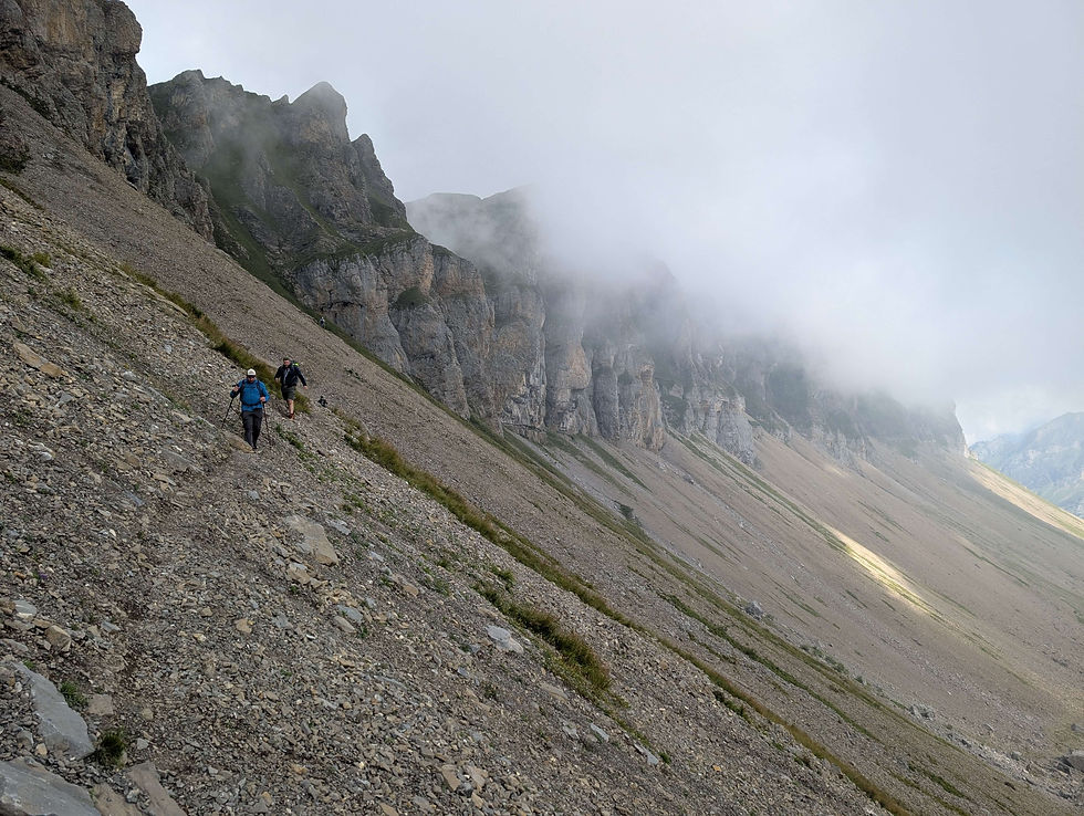
Following that path for quite a while, the debris eventually petered out and we at last had some grass back under our feet. Not much later, a turnoff appeared and while the shortest route back into civilization would have been another blue and white trail, none of us had any desire to scramble some more. :) Therefore, we just stayed on our path and when about five minutes later another junction appeared, we eventually were back on a red and white trail. Taking a right turn, we began to walk in the direction of Chinzig Chulm and absolutely didn't mind that it was the longer route, as we knew that it definitely also was the easier one. :) While the trail led over a bigger plateau at first, it descended through a lovely area afterwards, before it suddenly went upwards again. Oh boy, that was something we hadn't expected at all and it made the two ascending slopes we had to conquer quite a challenge. :) Fortunately, they weren't very long and at the end of the second one, the small chapel of Chinzig Chulm already had made its appearance. At the chapel we took a short break, before the long walk down to the cable car of Biel was upon us. A wide trail along a mountainside was leading the way and especially in the beginning the views were quite stunning, turning the descent almost into something like pleasure. :) Well, at least up to that point, where the clouds took over once more and barred all views. :)

Luckily, the clouds only rolled in again, once we had the best part of the steep mountainside behind us and therefore it didn't really matter. The last turnoff was basically also just around the corner and once we had reached it, we turned left onto an even wider trail that led down a bit more gently. Having no steep parts left to conquer, that last section simply was a very pleasant ending to our hike. Arriving at the restaurant in Biel, we sat down on the terrace, had our well-deserved beer and enjoyed it along with the sunshine that suddenly had appeared again. Afterwards, we took the cable car down into the valley, just to miss our bus by a couple minutes. Well, fortunately, the next one arrived already 20 minutes later, bringing us back to Flüelen, from where we took the train homewards to Zurich. :) Even though there were way too many clouds for our taste, the hike had been a real pleasure. As always, it was the company that made it such a good weekend, as we laughed a lot during those two days. So, thanks to my friends and I'm already looking forward to the hut hike of next year, hopefully then with a reservation earlier than April. :)
Highlights of the Weekend: the views between the Lidernen hut and Fulen on the second day and the company of my friends, although they basically were complaining nonstop :)
This hike is for you if:
- you're looking for a hut hike with plenty of trails in the area
- you want to sleep in a mountain hut even though the weather forecast is not very good
- you're looking for a family friendly hut
- you always wanted to take a swim in a mountain lake :)
This hike is not for you if:
- you've never scrambled before
- you don't like steep slopes
- you're looking for trails and peaks with no other people around


Comments